Nepal Earthquake: Tremors Felt on Tibet-Nepal Border, Nine Dead; Bihar Also Affected
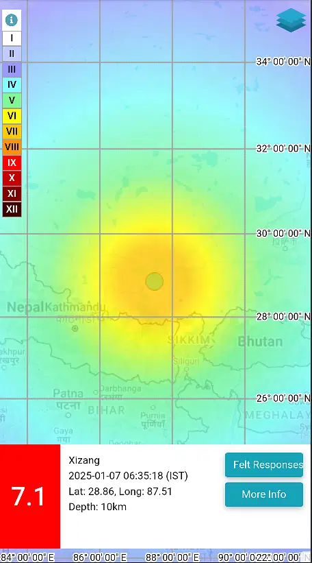
A powerful earthquake shook the Tibet-Nepal border early Tuesday morning, claiming at least nine lives in Tibet. The tremors, which struck at 6:35 am, had a magnitude of 7.1 on the Richter scale. The earthquake’s epicenter was located 93 kilometers northeast of Lobuche, Nepal. The quake was also felt in several Indian states, with Bihar experiencing the most significant impact. Tremors were also reported in parts of Assam, Sikkim, and West Bengal, prompting residents to evacuate their homes in fear.
According to the National Center for Seismology, the initial earthquake in Tibet occurred at a depth of 10 kilometers. It was followed by a series of aftershocks: a 4.7 magnitude quake at 7:02 am, a 4.9 magnitude quake at 7:07 am, and a 5.0 magnitude quake at 7:13 am. Despite the strong tremors, no casualties or significant property damage have been reported in these areas so far.
Recent Seismic Activity in Nepal
This earthquake follows another incident last month when a 4.8 magnitude quake struck Nepal on December 21. Nepal has a history of devastating earthquakes, with the most catastrophic in recent memory occurring in April 2015. The 7.8 magnitude earthquake in 2015 resulted in around 9,000 fatalities, injured 22,000 people, and destroyed over 800,000 homes and school buildings.
Why is Nepal Prone to Earthquakes?
According to Prof. Javed N Malik, a senior professor at IIT Kanpur specializing in Geoscience Engineering, the frequent seismic activity in Nepal is due to the instability of tectonic plates in the Himalayan region. The collision and movement of these plates generate significant geological energy, leading to frequent earthquakes.
Understanding Earthquakes: Causes and Measurement
Earthquakes occur due to the movement of Earth’s seven major tectonic plates. These plates continuously rotate and collide, creating fault lines. When the pressure from these collisions builds up and exceeds the strength of the Earth’s crust, the plates break, releasing energy and causing an earthquake.
The point directly above where this energy release occurs is known as the epicenter. The intensity of an earthquake is strongest at the epicenter and diminishes as the distance from the epicenter increases. However, earthquakes with a magnitude of 7 or higher can have a significant impact within a 40-kilometer radius.
Earthquake intensity is measured on the Richter scale, which ranges from 1 to 9. The scale measures the magnitude of energy released at the earthquake’s epicenter, helping to estimate the quake’s overall strength and potential impact.